
Definitely, the most of Europe is facing a quite mild and relatively warm, in average, December till now. However, there are hints that the circulation pattern will totally change before Christmas.
The current situation
Consecutive low pressure systems coming from the Atlantic ocean are affecting and will continue affecting the weather of western and northern Europe for the next ten days (so till 20/12/2019). This will not allow any significant cold outbreaks around Europe preserving a fairly mild weather and restricting any weather activity mainly in western and northern Europe (Iberia, eastern Italy, France, the UK and Scandinavia. In the meanwhile, the coldest corner of Europe will be (as usual) only the central and northern parts of Scandinavia.
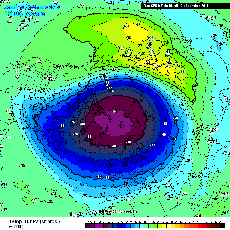
The lack of of cold outbreaks in Europe is depicted by the temperatures in the stratosphere over the north hemisphere (Figure 1). In particular, it seems that for the next ten days the north pole will be well isolated from the rest of the north hemisphere and will “put away” cold air.
What’s next and the hints
The first tool that we may use for estimating the future situation is the indices NAO and AO. During the last 24 hours, there is a small but maybe significant change of both these indices. AO index appears to drop to negative values around 20/12/2019. Similarly, NAO index decreases to slightly negative vales. Combining this information, we may conclude that according to NAO index, the Atlantic activity will weaken, and according to AO index, a cold outbreak may occur in Europe. However, this will not take place before 20/12/2019.
So, for the last ten days of this December, there is another clue supporting the change of the weather pattern. There have already been a few GFS ensemble members (almost 50% of them) predicting an establishment of an anticyclone over the Scandinavia. If something like that happens, the weather will get quite Christmasy in eastern and maybe southeastern Europe, while Christmas will be fairly dry in west and northwest Europe.
Stay tuned till our next article, which will come up once we get more reliable data about the period around C
Μετά τις 20/12/2019 διαφαίνονται και κάποια σενάρια εγκαθίδρυσης Σκανδιναβικού αντικυκλώνα, όπως φαίνεται και στα προγνωστικά μέλη του GFS για την περιοχή της νότιας Νορβηγίας (σχήμα 2). Πιο συγκεκριμένα, σχεδόν το 50% των μελών αυτή τη στιγμή “βλέπουν” την ανάπτυξη υψηλών πιέσεων στην περιοχή. Αν αυτό συμβεί, τότε θα επιτραπεί σε ψυχρότερες αέριες μάζες από τη Ρωσία να κατέλθουν νοτιότερα.