Having experienced an extra mild winter across the entire Europe, this is actually the first time that the atmospheric circulation looks interesting.
Support out weather team following our facebook, youtube channel and Instagram.
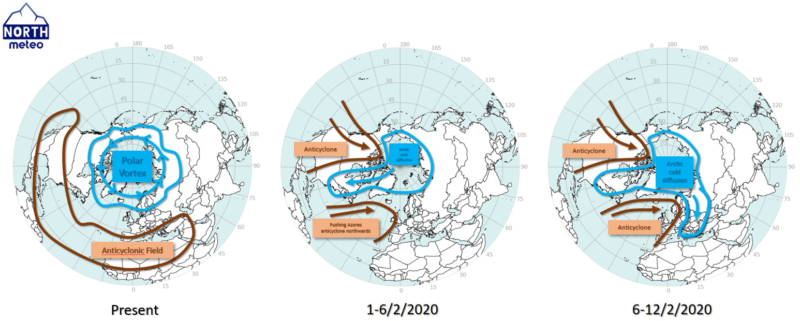
There are remarkable signs showing that the weather will change within February spreading arctic cold and snow in Europe. The cause is the already predicted breaking of the polar vortex during the current week. We should make clear that when we say “polar vortex” we refer to a solid cold air mass with a structure along the profile of the troposphere reaching the stratosphere, which is located geographically within the arctic circle. One of the reasons that this vortex is developed during the winter is the lack (or the limited) sunlight.
When this air mas breaks being intruded by anticyclonic systems, then the equilibrium in the circulation of the north hemisphere is perturbed and a part of this cold air mass moves southwards.
This time, there are reliable signs that the weather will change significantly in Europe this last month of the winter. In early February, we should expect one severe cold outbreak in northeast America, which should come with severe cold and snow there. However, this will be just the beginning as it will affect through a domino effect the weather of Europe perturbing the equilibrium between cold and warm air masses in north hemisphere (figure 1).
For now, it is a bit of unknown how exactly this arctic mass will move over Europe. The most of scenarios keen on moving the cold to the central/east of Europe. However, there are a few possibilities that this arctic mass will move westwards.
In any case, every meteorologist that respect himself and his scientific identity should highlight the fact that all this syllogism is based in possibilities and it is not a forecast yet.
